You can’t talk of a country with amazing world heritage sites without including Zimbabwe. A country that has built its beauty around the cycle of tourism, making it home to adventurers.
If we take a brief look around, we will Behold Victoria Falls which is a magnificent waterfall from a cliff, coming closer to the parks you will witness some unique wild animals that made Zimbabwe the soul of adventure, and stretching below the horizon is a pure lake (a home for fishery and paradise for relaxation).
If you are thinking of taking a trip for sightseeing in Zimbabwe, our list below will be essential for your magical experience.
We will discuss:
Without further ado, let us begin.
1. Great Zimbabwe National Monument
Great Zimbabwe National Monument is approximately 30 km from Masvingo and located in the Lowveld at an altitude of some 1100 m in a sparsely populated region of the Bantu/Shona people.
The property, built between 1100 and 1450 AD, extends over almost 800 ha and is divided into three groups: the Hill Ruins, the Great Enclosure, and the Valley Ruins.
The Hill Ruins, forming a huge granite mass atop a spur facing north-east/south-west, were continuously inhabited from the 11th to 15th centuries, and there are numerous layers of traces of human settlements. Rough granite rubble-stone blocks form distinct enclosures, accessed by narrow, partly covered, passageways.
This acropolis is generally considered a ‘royal city’; the west enclosure is thought to have been the residence of successive chiefs and the east enclosure, where six steatite upright posts topped with birds were found, considered to serve a ritual purpose.
The Great Enclosure, which has the form of an ellipsis, is located to the south of the hills and dates to the 14th century. It was built of cut granite blocks, laid in regular courses, and contains a series of daga-hut living quarters, a community area, and a narrow passage leading to a high conical tower.
The bricks (daga) were made from a mixture of granitic sand and clay. Huts were built within the stone enclosure walls; inside each community area other walls mark off each family’s area, generally comprising a kitchen, two living huts and a court. The Valley Ruins are a series of living ensembles scattered throughout the valley which date to the 19th century.
Each ensemble has similar characteristics: many constructions are in brick (huts, indoor flooring and benches, holders for recipients, basins, etc.) and dry stone masonry walls provide insulation for each ensemble.
Resembling later developments of the Stone Age, the building work was carried out to a high standard of craftsmanship, incorporating an impressive display of chevron and chequered wall decorations.
Scientific research has proved that Great Zimbabwe was founded in the 11th century on a site which had been sparsely inhabited in the prehistoric period, by a Bantu population of the Iron Age, the Shona. In the 14th century, it was the principal city of a major state extending over the gold-rich plateaux; its population exceeded 10,000 inhabitants.
About 1450, the capital was abandoned because the hinterland could no longer furnish food for the overpopulated city and because of deforestation. The resulting migration benefited Khami, which became the most influential city in the region, but signaled waning political power.
When in 1505 the Portuguese settled in Sofala, the region was divided between the rival powers of the kingdoms of Torwa and Mwene-Mutapa. Archaeological excavations have revealed glass beads and porcelain from China and Persia, and gold and Arab coins from Kilwa which testify to the extent of long-standing trade with the outer world.
Other evidence, including potsherds and ironware, gives a further insight to the property’s socio-economic complexity and about farming and pastoral activities. A monumental granite cross, located at a traditionally revered and sacred spiritual site, also illustrates community contact with missionaries.
2. Khami Ruins National Monument
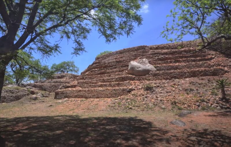
Khami Ruins National Monument is located to the west of the Khami River, 22 km from the City of Bulawayo. The property, located on a 1300 m hilltop downstream from a dam built during 1928-1929, covers an area of about 108 ha, spread over a distance of about 2 km from the Passage Ruin to the North Ruin.
The property was the capital of the Torwa dynasty, which arose from the collapse of the Great Zimbabwe Kingdom between 1450 -1650 and was abandoned during the Ndebele incursions of the 19th century. It is composed of a complex series of platforms of dry-stone walled structures, emulating a later development of Stone Age culture.
The chief’s residence (Mambo) was located towards the north on the Hill Ruin site with its adjacent cultivation terraces. The population lived in daga huts of cobwork, surrounded by a series of granite walls.
These structures display a high standard of workmanship, a great number of narrow passageways and perambulatory galleries and impressive chevron and chequered wall decorations.
Khami conforms to Great Zimbabwe in a number of archaeological and architectural aspects but it possesses certain features particular to itself and its successors such as Danangombe and Zinjanja.
Revetments or retaining walls found expression for the first time in the architectural history of the sub-region at Khami, and with it were elaborate decorations; it still has the longest decorated wall in the entire sub-region.
The architecture of the site and the archaeological artefacts provide evidence for an exceptional understanding of strong, united, early civilizations.
They also offer information on the property’s complex socio-economic, religious and spiritual significance for the local communities and for the overall chronological development of Zimbabwe tradition; initiated in Mapungubwe (South Africa), extending to Great Zimbabwe, and through the emergence of later states.
The archaeological remains are also a testament to long-distance historic trade links with the Portuguese, and the wider world, the diverse range of imported artefacts provide evidence of 15th and 17th century Spanish porcelain, Rhineland stoneware and Ming porcelain, many of which are on display in the Museum of Natural History in Bulawayo.
There is also a monumental granite cross which illustrates the contact with missionaries at a traditionally revered and sacred spiritual site. Khami is the second largest stone built monument in Zimbabwe. Its historical importance lies in its position at the watershed between the history of Great Zimbabwe and the later Zimbabwe period.
It is one of the few Zimbabwe sites that were not destroyed by treasure hunters and its undisturbed stratigraphy is scientifically important in providing a much clearer insight into the history of the country. The climate supports a natural vegetation of open woodland, dominated by Combretum and Terminalia trees.
Being close to the Kalahari Desert, the area is also vulnerable to droughts, and rainfall tends to vary considerably. The property has suffered some degradation due to variations in temperature, ground water, tourism, encroaching vegetation and applied preservation techniques.
3. Matobo Hills
The Matobo Hills some 35 km south of Bulawayo are a profusion of distinctive granite landforms, densely packed into a comparatively tight area, that rise up to form a sea of hills. Their forms have resulted from the varied composition and alignment of the granite rocks, which responded differently to millions of years of weathering.
These extraordinary granite rock formations have exerted a strong presence over the whole area – both in natural and cultural terms. People have interacted with, and been inspired by, the dramatic natural rock formations of the Matobo Hills for over many millennia.
This interaction has produced one of the most outstanding rock art collections in southern Africa; it has also fostered strong religious beliefs, which still play a major role in contemporary local society; and it demonstrates an almost uninterrupted association between man and his environment over the past 100,000 years.
The Matobo Hills have one of the highest concentrations of rock art in Southern Africa dating back at least 13,000 years. The paintings illustrate evolving artistic styles and also socio-religious beliefs. The whole bears testimony to a rich cultural tradition that has now disappeared.
The rich evidence from archaeology and from the rock paintings at Matobo provides evidence that the Matobo Hills have been occupied over a period of at least 500,000 years.
Furthermore, this evidence provides a very full picture of the lives of foraging societies in the Stone Age and the way agricultural societies eventually came to displace them in the Iron Age. The Mwari religion which is still practiced in the area, and which may date back to the Iron Age, is the most powerful oracular tradition in southern Africa.
The Matobo rocks are seen as the seat of god and of ancestral spirits. Sacred shrines within the hills are places where contact can be made with the spiritual world. The living traditions associated with the shrines represent one of the most powerful intangible traditions in southern Africa and one that could be said to be of universal significance.
This is a community response to a landscape rather than individual ones. The natural qualities of Matobo, in terms of the power of the rocks and of the produce from the surrounding natural environment, thus have strong cultural associations.
4. Mana Pools National Park, Sapi and Chewore Safari Areas

The Mana Pools National Park, Sapi and Chewore Safari Areas World Heritage Site is an area of dramatic landscape and ecological processes.
Physically protected by the Zambezi River to the north and the steep escarpment (which rises to over 1,000 m from the valley floor) to the south, this substantial property of 676,600 ha provides shelter for immense congregations of Africa’s large mammal populations which concentrate in its flood plains.
The Mana Pools are former channels of the Zambezi River, and ongoing geological processes present a good example of erosion and deposition by a large seasonal river including a clear pattern of plant succession on its alluvial deposits.
While black rhino has disappeared since the property’s inscription, huge herds of elephant and buffalo, followed by zebra, waterbuck and many other antelope species and their associated predators including lion and hyena migrate to the area each year during the dry winter months.
The river is also famous for its sizeable numbers of hippopotamus and Nile crocodile. Resident and migratory birdlife, with over 450 species recorded, is also abundant. Controlled hunting on quota is permitted in the safari areas.
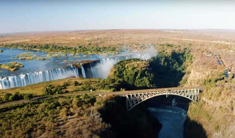
5. Mosi-oa-Tunya / Victoria Falls
The Mosi-oa-Tunya/Victoria Falls is the world’s greatest sheet of falling water and significant worldwide for its exceptional geological and geomorphological features and active land formation processes with outstanding beauty attributed to the falls i.e. the spray, mist and rainbows.
This transboundary property extends over 6860 ha and comprises 3779 ha of the Mosi-oa-Tunya National Park (Zambia), 2340 ha of Victoria Falls National Park (Zimbabwe), 741 ha of the riverine strip of Zambezi National Park (Zimbabwe).
A riverine strip of the Zambezi National Park extending 9 km west along the right bank of the Zambezi and islands in the river are all within the Park as far as Palm and Kandahar Islands, with the Victoria Falls being one of the major attractions.
The waterfall stands at an altitude of about 915 m above mean sea level (a.m.s.l.) and spans to about 1708 m wide with an average depth of 100 m and the deepest point being 108 m.
Sprays from this giant waterfall can be seen from a distance of 30 km from the Lusaka road, Zambia and 50 km from Bulawayo road, Zimbabwe. Basalts have been cut by a river system producing a series of eight spectacular gorges that serve as breeding sites for four species of endangered birds.
The basalts of the Victoria Falls World Heritage property are layered unlike those of the Giants Causeway World Heritage site which are vertical and columnar.
FAQs
How many sites are on the World Heritage List?
There are 1,199 sites listed on the UNESCO World Heritage List.
What are 2 sacred places in Zimbabwe?
Two sacred places in Zimbabwe are the Matobo Hills, known for their rock art and spiritual significance, and the Mabweadziva/Chinhoyi Caves, revered for their historical and cultural importance.
What are the 5 cultures in Zimbabwe?
Zimbabwe is home to several cultures, with the five most prominent being the Shona, Ndebele, Tonga, Chewa, and Venda peoples, each with its unique traditions, languages, and customs.
Why are heritage sites important in Zimbabwe?
Heritage sites in Zimbabwe are important as they preserve and showcase the country’s rich history and cultural diversity, contribute to national identity and pride, and are crucial for education and tourism.
The Bottom Line
Zimbabwe’s World Heritage Sites offer a captivating glimpse into the country’s rich history, culture, and natural beauty. From the awe-inspiring Victoria Falls to the ancient ruins of Great Zimbabwe, each site tells a unique story of the land and its people.
The Matobo Hills and Mana Pools National Park showcase Zimbabwe’s diverse and vibrant ecosystems, while the Khami Ruins reveal the complexity of past civilizations. These sites are not just tourist destinations; they are treasured reminders of our shared human heritage and the importance of preserving such wonders for future generations.